8.3 Legislation, Standards & Guidelines
8.5 Fisheries Baseline – Literature Review
8.6 Fishery Baseline – Field Surveys
8.7 Construction Phase Impact Assessment
8.8 Operational Phase Impact Assessment
8.10 Mitigation Measures & Best Practice
8.11 Residual Impact Assessment
8.12 Environmental Monitoring & Audit Requirements
8.13
Conclusions & Recommendations
8.1.1.1 This section presents the approach to and the findings of the fisheries baseline assessment and the project impact assessment.
8.1.1.2 The purpose of the assessment is to examine all fisheries resources within the assessment area to ensure their protection.
8.2.1.1 The aim of the fisheries impact assessment is to evaluate baseline conditions and assess the potential short-term and long-term impacts on the local fishing industry from development of the proposed Project.
8.2.1.2
The fisheries impact assessment
has been conducted in accordance with the criteria and guidelines in Annexes 9
and 17 respectively of the EIA-TM, and with reference to the following
requirements as stated in Clause
· Review the findings of relevant studies/surveys and collate the available information regarding the ecological characters of the assessment area;
·
Describe the physical environment background and describe and quantify
existing capture and culture fisheries activities;
·
Identify and quantify any impacts of fisheries during Project
construction and operation;
·
Evaluate impacts and make recommendations for any mitigation measures
required to protect fisheries, including inter
alia staff and financial implications for subsequent management and
maintenance; and
·
Review the need for monitoring and, if necessary, recommend a monitoring
and auditing programme.
8.3 Legislation, Standards & Guidelines
8.3.1.1 In addition to the requirements of the EIAO (Cap. 499), the following statutory requirements are also applicable:
·
Fisheries Protection Ordinance (Cap. 171) exists “to promote the conservation of fish and other forms of aquatic
life within the waters of
· Marine Fish Culture Ordinance (Cap. 353) exists to protect any fish in any fish culture zones from being injured; as well as to protect the waters in fish culture zones from pollution.
8.4.1 Desk-top Review
8.4.1.1 A desk top review was undertaken to provide background data and information on the development of local commercial fisheries. Key references included various research studies and scientific papers from local tertiary institutes, and data from Port Survey 1996/1997, 2001/2002 and 2006.
8.4.2 Geophysical Survey
8.4.2.1 A marine geophysical survey was conducted in August 2006 to detect anomalies on the seabed. This survey is able to produce a record of substrate type and condition, and is a useful method for indicating the intensity of trawling activity in offshore waters. Trawl marks may be identified by side-scan sonar that clearly represents the surface profile across the surveyed areas. Distinctive ploughing features may be evident, from trawling and readily identified"
8.4.3 Marine Radar Data Analysis
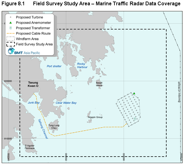
8.4.3.1
In parallel with the EIA Study,
BMT conducted a Marine Navigational Safety Risk Assessment (MNSRA) for the
Project. Marine traffic radar data collected between June and September 2006
were analysed to es
8.4.3.2 The collected radar data provided information on vessel movements, including the position (in terms of x and y), vessel speed, direction and vessel length & beam. Using this data it was possible to isolate data specifically associated with fishing vessels to generate a credible representation of the intensity of fishing activity.
8.4.3.3
Historical data cited by Leung
(2003) indicated that active trawlers in HKSAR waters operate at less than 6
knots and have a typical length up to 40 metres as presented in Table 8.1 and Table 8.2,
respectively.
8.4.3.4 The radar data sought to discriminate fishing vessels from other types of vessels using the following criteria proposed by BMT, however it is noted that the particular type of vessel cannot be defined :
· Sizes < 40 metres
· Conservative trawling speed < 6 knots; and
· Looping route patterns characteristic of trawling activity.
Table 8.1 Typical Trawling Speed
|
Pair & stern trawl1 |
Shrimp trawl2 |
Unit |
|
3.1 |
3 |
Nm/hr |
|
5.7 |
5.6 |
Km/hr |
Notes: 1.
AFCD Pair and Stern Trawl Survey (1992 – 1995)
2. AFCD’s Shrimp Trawl
Survey (1981 – 1982)
Source:
Leung A.W.Y. (2003).
Table 8.2 Typical Vessel Sizes
|
Size (m) |
Total |
Pair trawler |
Stern trawler |
Hang trawler |
Beam trawler |
Long liner |
Hand liner |
Gill netter |
Purse seiner |
Maricraft* |
Miscellaneous |
|
Distribution (m) |
|||||||||||
|
<5.00 |
252 |
|
|
|
|
11 |
20 |
57 |
1 |
139 |
24 |
|
5.0 - 9.9 |
2,325 |
|
|
|
21 |
103 |
30 |
185 |
27 |
1,593 |
366 |
|
10.0 - 14.99 |
455 |
|
|
1 |
44 |
58 |
48 |
134 |
76 |
3 |
91 |
|
15.0 - 19.99 |
254 |
5 |
27 |
2 |
100 |
52 |
18 |
29 |
17 |
4 |
|
|
20.0 - 24.99 |
563 |
39 |
101 |
4 |
246 |
73 |
51 |
30 |
1 |
|
|
|
25.0 - 29.99 |
736 |
381 |
82 |
12 |
97 |
47 |
46 |
71 |
|
|
|
|
30.0 - 34.99 |
218 |
156 |
11 |
6 |
7 |
16 |
1 |
21 |
|
|
|
|
>35.0 |
6 |
4 |
1 |
|
|
1 |
|
|
|
|
|
|
All Sizes |
4,809 |
585 |
222 |
25 |
515 |
361 |
214 |
527 |
122 |
1,739 |
499 |
|
Mean size (m) |
18.8 |
28.5 |
24.2 |
26.1 |
20.8 |
16.8 |
18.3 |
14.8 |
12.5 |
5.6 |
8.5 |
Note:
* Mariculture craft
Source: Leung A.W.Y. (2003).
8.4.3.5
Table 8.2 supports
the view that any assessment of fishing vessel activity from remote sensing by
radar should focus on the movement of
vessels of under 40m Length.
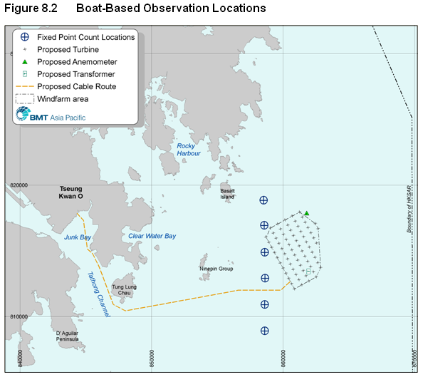
8.4.4 Boat-Based Observations of Fishing Activity
8.4.4.1
An opportunistic series of
boat-based observations were conducted between January and July
8.4.5 Semi-Structured Fishermen Survey
8.4.5.1
With the assistance of a group
of retired fishermen, a focussed questionnaire was developed with which to
interview fishermen from Shau Kei Wan, Lei Yue Mun, Sai Kung and
8.4.5.2 A large proportion of fishing activity in Eastern Waters is derived from Shau Kei Wan. Thus, this survey group is familiar with fishing activity in the Study Area.
8.4.5.3 Sai Kung and Lei Yue Mun represent two homeports in relative proximity to the Study Area that traditionally fished in Eastern Waters. Both of these homeports support only a small number of boats still engaged in fishing, with many boat owners having made the transition into other industries.
8.4.5.4
8.4.5.5 The costs of operating fishing vessel, notably fuel costs, generally preclude significant fishing activity in the Study Area derived from other homeports.
8.4.5.6 The survey sample size was targeted at around 70 interviewees, with this target being roughly double those from previous semi-structured surveys (Sumaila et al, 2007; Sadovy et al., 2004).
8.4.5.7 The survey questionnaire was developed to collect the following information:
· Crew size & nationality;
· Primary fishing grounds, fishing effort and fishing seasons;
· Target species;
· Commonly caught species;
· Reasons for selection of primary fishing grounds; and more generally
· Actual and perceived threats to the fishing industry and the most effective ways to increase fisheries resources in Eastern Waters.
8.4.5.8
The target interviewees were
boat captains who manage and / or own fishing vessels > 15 m that are
capable of operating in exposed waters.
The questionnaire is presented in Appendix
8.5 Fisheries Baseline – Literature Review
8.5.1
Historical Overview of
8.5.1.1
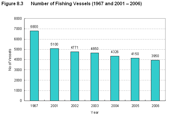
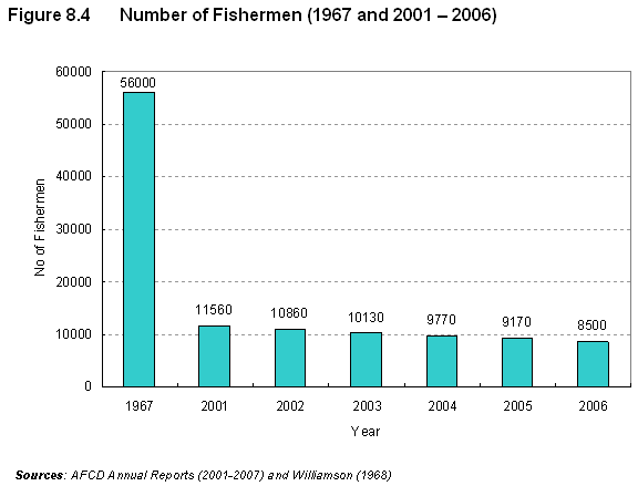
From the second half of the 20th
century the local commercial fishing industry has experienced various
transitions. Government loans in the
1950s enabled rapid growth in fleet size and fishing effort and, with improvements
in fishing equipment, by the 1960s there had been a substantial increase in the
size of the capture fisheries industry.
The catch per unit effort for trawlers at this time was ~90
8.5.1.2
By the 1970s the decline of the
industry was becoming apparent, with smaller pelagic fish such as sardines the
dominant catch and the catch per unit effort showing signs of decline. In the
1980s species such as groupers and croakers had become uncommon catches and a
general decline in the finfish catch was observed, with the trawler catch per
unit effort having fallen to ~
8.5.1.3
By the end of the 1990s the
local catch of fishes and
invertebrates had declined significantly over the prior 50 years, with an es
8.5.1.4
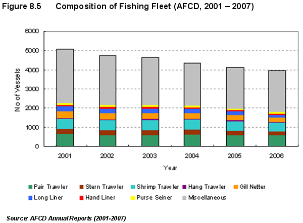
Figure 8.5 shows that the greatest decline in vessel category
is a ~30% drop in ‘miscellaneous’ craft which comprise small boats employing
lining, netting and trapping techniques to target more expensive species like
rockfish and snapper (Sumaila et al,
2007). This decline reflects a general
decrease in catch size and quality.
8.5.2 Capture Fisheries in the Study Area
8.5.2.1 Table 8.3 summarises the top ten most commonly caught species reported by the three Port Surveys conducted in 1996/1997, 2001/2002 and 2006. The similarity in species composition suggests the marine ecosystem stabilised at a depressed level between surveys.
Table 8.3 Top 10 Most Commonly Caught Species
|
Rank |
96/97 Port Survey |
01/02 Port Survey |
2006 Port Survey |
|
1 |
Mixed fish |
Mixed fish |
Mixed fish |
|
2 |
Scad |
Rabbit fish |
Scad |
|
3 |
Sardine |
Sardine |
Shrimp |
|
4 |
Croaker |
Croaker |
Rabbit fish |
|
5 |
Anchovy |
Scad |
Squid |
|
6 |
Crab |
Squid |
Croaker |
|
7 |
Rabbit fish |
Shrimp |
Crab |
|
8 |
Shrimp |
Anchovy |
Mullet |
|
9 |
Pony Fish |
Crab |
Sardine |
|
10 |
Rock fish |
Sea bream |
Sea bream |
8.5.2.2 In order to enable a comparison of fishing activity, Table 8.4 presents an indicative ranking system developed with reference to Port Surveys 2001/2002 and 2006.
Table 8.4 Fishing Activity Ranking
|
Ranking |
Number of Fishing Vessels active in region (*) |
|
None |
0 |
|
Negligible |
>0 & £10 |
|
Very Low |
10 – 50 |
|
Low |
50 – 100 |
|
Moderate |
100 – 400 |
|
High |
400 – 700 |
|
Very High |
700 – 1000 |
(*) http://www.afcd.gov.hk/english/fisheries/fish_cap/fish_cap_latest/fish_cap_latest.html
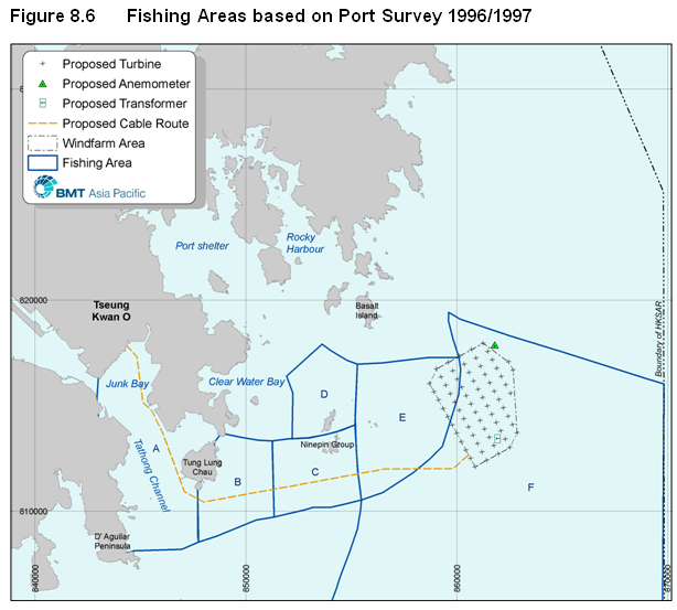
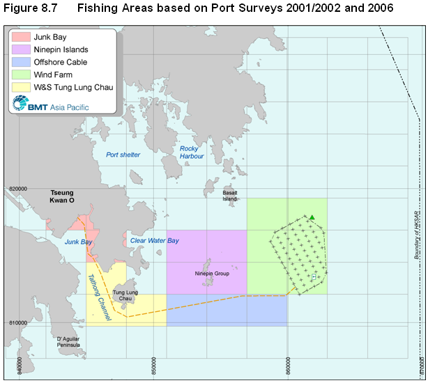
8.5.2.3 Figure 8.6 and Figure 8.7 illustrate the coverage and the zonation of fishing areas from the Port Survey studies across the Study Area.
8.5.2.4
Table 8.5 summarises the level of fishing activity within the Study Area
based on the Port Survey studies. It
appears that only small number of vessels >15 m length (classed as large
vessels for the purposes of this assessment) operate within the Study Area,
with most found around the Ninepin
8.5.2.5 Vessel use of the fishing areas defined for Port Survey 2001/02 and 2006 is more easily interpreted, and the dominance of vessels < 15 m length (classed as small vessels) in coastal waters is evident.
Table 8.5 Fishing Activity in the Selected Fishing Areas
|
Port
Survey |
Area |
Vessels
< |
Vessels
> |
|
1996/1997 |
Zone A |
Very High |
Very Low |
|
Zone B |
Moderate |
Very Low |
|
|
Zone C |
Moderate |
Very Low |
|
|
Zone D |
Moderate |
Very Low |
|
|
Zone E |
Moderate |
Very Low |
|
|
Zone F |
Negligible |
Negligible |
|
|
2001/2002
and 2006 |
Tseung Kwan O |
Moderate |
Negligible |
|
Tung Lung Chau |
Moderate / High |
Negligible / Very Low |
|
|
|
Very Low / Moderate |
Low / Moderate |
|
|
Ninepins |
High / Very High |
Moderate |
|
|
Wind Farm |
Negligible / Very Low |
Very Low / Moderate |
8.5.2.1 With reference to the above table, Port Survey data consistently suggests there is little fishing activity in offshore waters, although the Port Survey 2006 data notably suggests an increase in larger vessels activity in the vicinity of the proposed wind farm relative to both earlier Port Surveys (i.e., “Negligible / Very Low” (1996/97), “Very Low” (2001/02) and “Very Low / Moderate” (2006)).
8.5.2.2 Port Survey 2006 data also suggests that fishing activity by small and large vessels alike in all areas of offshore Eastern Waters (north and south) except near the proposed wind farm remains “Negligible / Very Low”. Except for this change in perception there is no objective evidence of increased productivity in offshore fishing activity specifically near or adjacent to the proposed wind farm.
8.5.2.3
A baseline review of capture fisheries productivity has also been
conducted. Table
8.6 displays a productivity ranking system that has been devised based on Port Survey 2001/02 and 2006 to support the baseline
review.
Table 8.6 Fisheries Productivity
Ranking
|
Ranking |
Overall Value (HK$ / ha) |
Adult Fish (kg / ha) |
Fry (tails / ha) |
By Species (kg / ha) |
|
None |
0 |
0 |
0 |
0 |
|
Negligible |
>0 & £500 |
>0 & £50 |
>0 & £50 |
£5 |
|
Very Low |
500 – 1K |
50 – 100 |
50 – 100 |
5 – 10 |
|
Low |
1K – 2K |
100 – 200 |
100 – 500 |
10 – 20 |
|
Moderate |
2K – 5K |
200 – 400 |
500 – 1k |
20 – 40 |
|
High |
5K – 10K |
400 – 600 |
1K – 2K |
40-60 |
|
Very High |
10K– 20K |
600 – 1K |
2K – 3K |
>60 |
8.5.2.4 Table 8.7 summarises the relative productivity of capture fisheries in the Study Area using the ranking system displayed in Table 8.6.
Table 8.7 Fish Productivity across the Study Area
|
Port
Survey |
Area |
Overall
Value (HK$
/ ha) |
Adult
Fish (kg
/ ha) |
Fry (tails
/ ha) |
|
1996/1997 |
Zone A |
High |
Low |
Very Low |
|
Zone B |
Moderate |
Low |
Negligible |
|
|
Zone C |
Moderate |
Moderate |
Very Low |
|
|
Zone D |
Moderate |
Moderate |
Very Low |
|
|
Zone E |
Moderate |
Low |
Negligible |
|
|
Zone F |
Negligible |
Negligible |
None |
|
|
2001/2002 and 2006 |
Tseung
Kwan O |
Moderate |
Low |
Negligible |
|
Tung
Lung Chau |
Moderate / High |
Low / High |
Negligible |
|
|
|
Low / Moderate |
Low / Moderate |
Negligible |
|
|
Ninepins |
High / Very High |
Very High |
Negligible |
|
|
Wind
Farm |
Negligible / Low |
Negligible / Low |
None / Negligible |
8.5.2.5
From the above table it is
apparent that the reported productivity of capture fisheries in the Study Area
of the proposed project has remained fairly stable over the past decade. The Port Survey data from 2001/02 and 2006
suggests that overall dollar catch value and adult fish productivity is
consistently high around the
8.5.2.6 All three Port Survey studies indicate that Eastern Waters has negligible or very low fish fry productivity, and this suggestion is consistent with the findings of the systematic ichthyoplankton surveys conducted in Eastern Waters in 1994 as referred in sub-section 6.5.
8.5.2.7 As regards the species present in the Study Area and making use of data from the latest Port Survey 2006, Table 8.8 presents the most commonly caught species in HKSAR waters (Table 8.3 refers) and presents the productivity of each of these species across the Study Area.
Table 8.8 Productivity of Top HKSAR Species in the Study Area
|
Fish Species |
Tseung Kwan O |
W & S Tung
Lung Chau |
Offshore Cable |
Ninepins |
Wind Farm |
|
Scad |
Negligible |
Negligible |
Very Low |
Very High |
Negligible to Low |
|
Shrimp |
Negligible |
Negligible |
Low to Moderate |
Low to Moderate |
Negligible to Moderate |
|
Rabbitfish |
Moderate to High |
Moderate |
Very Low |
Moderate |
Negligible |
|
Squid |
Negligible |
Negligible |
Low |
High to Very High |
Negligible to Very Low |
|
Croaker |
Negligible to Very Low |
Very Low to Low |
Very Low |
Moderate |
Negligible to Very Low |
|
Crab |
Very Low to Low |
Low |
Very Low |
Low |
Negligible to Low |
|
Mullet |
Negligible |
Negligible |
Negligible |
Low |
None to Negligible |
|
Sardine |
Negligible to Very Low |
Negligible to Very Low |
Very Low |
Low |
Negligible |
|
Seabream |
Low to Moderate |
Very Low to Low |
Negligible |
Low |
Negligible |
Source: AFCD, Port Survey 2006 (no data available for ‘mixed fish’)
8.5.2.8 The above data displays the generally negligible productivity for the most common species in the vicinity of the wind farm, although productivity for certain species is locally high around the Ninepins. Productivity of all other HKSAR-wide common species is generally not high in other waters of the study area.
8.5.3 Mariculture in the Study Area
8.5.3.1
Common mariculture species in
the HKSAR are various species of groupers and snappers, and pompano. Fry for mariculture are mainly imported from
the Mainland (PRC),
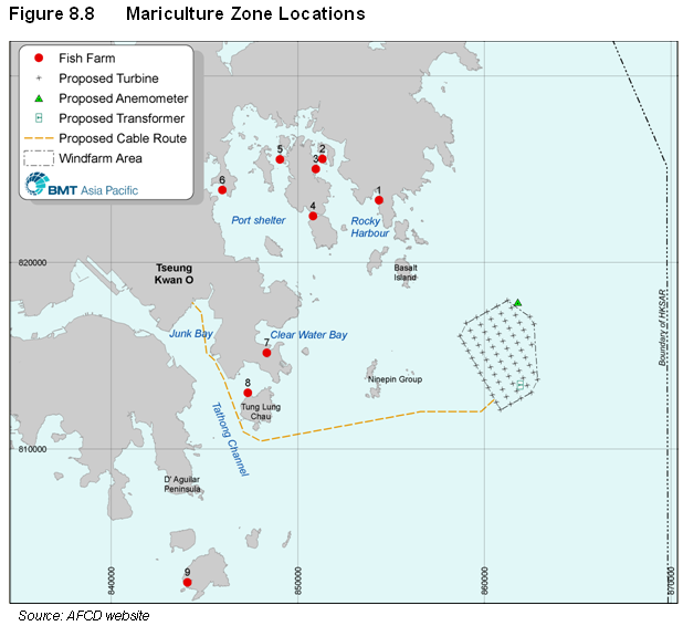
8.5.3.2 There are currently 1,066 licensed mariculture operators across 26 fish culture zones in the HKSAR, with these zones collectively occupying a surface area of ~209 hectares. Nine of the 26 fish culture zones are located in the vicinity of the Study Area. Table 8.9 summarises the nine zones, with their locations displayed by Figure 8.8.
8.5.3.3
Tung Lung Chau is the largest
fish culture zone in the Study Area and is understood to function, in part, as a
temporary holding area for imported live fish (pers com). This fish culture zone is also the closest to
proposed dredging works at
Table 8.9 Summary of Fish Culture Zones in the Study Area
|
ID |
Fish
Culture Zones |
|
1 |
Leung Shuen Wan |
|
2 |
Tai Tau Chau |
|
3 |
Tiu Cham Wan |
|
4 |
Kau Sai |
|
5 |
Kai Lung Wan |
|
6 |
Ma |
|
7 |
|
|
8 |
Tung Lung Chau |
|
9 |
|
Source: AFCD, 2008
8.5.4 Spawning and Nursery Sites
8.5.4.1 Key species recorded by the 1998 Fisheries Resources and Fisheries Operations report that spawn in eastern inshore waters include Apogon Quadrifasciatus (Twostripe cardinal), Parapristipoma Trilineatum (Chicken grunt), Sebasticus Marmoratus (False Kelpfish), Trichiurus Haumela (Hairtail), Upeneus Sulphureus (Sulphur goatfish) and Upeneus Tragula (Freckled goatfish).
8.5.4.2
The 1998 report notes that
areas in eastern inshore waters of Sai Kung and including the coastal perimeter
of
8.5.4.3
The wind farm footprint lies
more than 4km away from the identified spawning grounds in eastern
8.5.4.4
The 1998 report also identifies
that the most important nursery sites of commercial species in Hong Kong lie in
Northeast Waters, within Port Shelter, south of
8.6 Fishery Baseline – Field Surveys
8.6.1 Marine Geophysical Survey
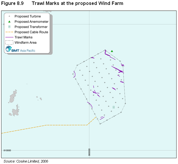
8.6.1.1 As illustrated by Figure 8.9, the side scan sonar survey was able to identify discreet trawl marks on the seabed at the proposed wind farm area. These marks are relatively sparse across an area of about 16km2, suggesting that trawling is limited.
8.6.1.2 However, it may be considered that trawl marks do not easily persist in the soft sediments of the wind farm site, and hence are not an absolute marker of trawling activity, but may provide information on the distribution. On this basis it is identified that the principal area for trawling activity is focussed on the north-east corner of the site.
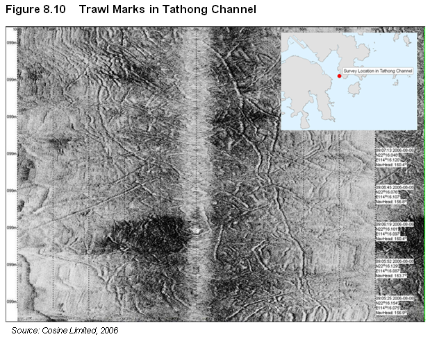
8.6.1.3 Figure 8.10 illustrates a sample of trawl marks, in this case from the firmer sediments of the Tathong Channel.
8.6.2 Marine Traffic Radar Data Analysis
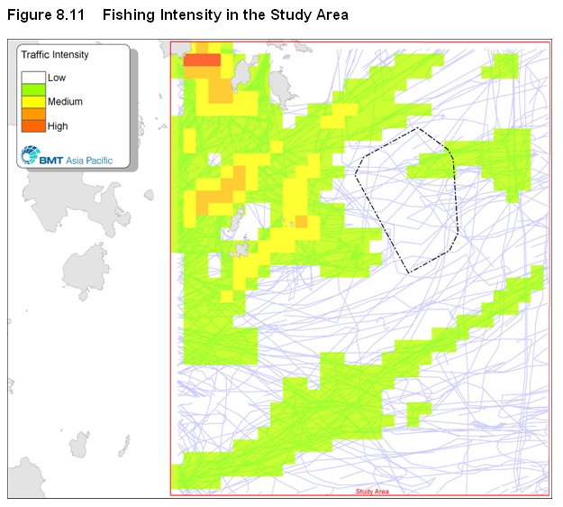
8.6.2.1
Figure 8.11 illustrates the
distribution of sampled fishing activity between June and early July, during
the fishing moratorium in the
8.6.3 Boat-Based Observations
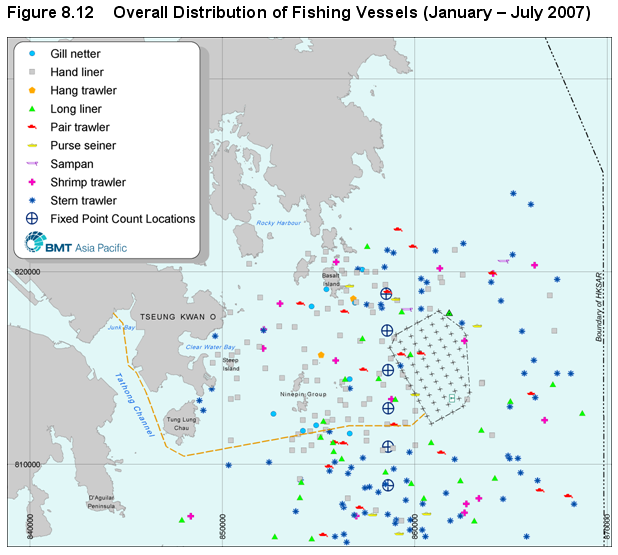
8.6.3.1 Figure 8.12 displays all fishing vessels recorded during boat-based observations between January and July 2007. More detail on vessel observations is presented in Appendix 8B.
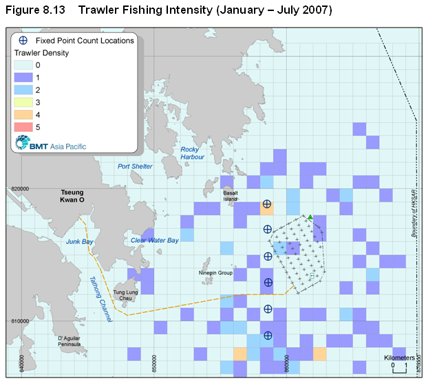
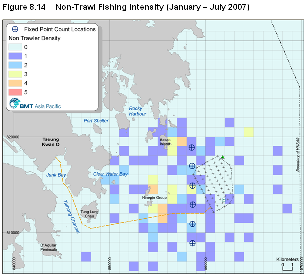
8.6.3.2 In order to facilitate data analysis vessels were broadly divided into two categories: trawlers and non-trawlers. Trawlers include stern, pair, hang and shrimp trawlers, while non-trawling vessels comprise purse seiners, gill-netters, long liners, hand liners and sampans. Figure 8.13 and Figure 8.14 display the density of trawler and non-trawler vessels, respectively.
8.6.3.3 It is apparent that the densities in these figures corresponds strongly with the findings of the Marine Radar Data Analysis (Figure 8.11 refers) and with data from the Port Survey studies (Table 8.5 refers).
8.6.3.4 Figure 8.13 indicates that trawling is concentrated in waters south of the wind farm, with some activity in waters to the northwest and east of the wind farm, but little within the proposed wind farm area. Figure 8.14 illustrates that non-trawling activity is focussed around more sheltered islands, notably west of the Ninepin Islands and Basalt Island, although there were also observations of these small vessels offshore when sea state was very calm (i.e., Beaufort scale ≤ 2). The activity of small vessels near the proposed wind farm appears to be very low.
8.6.3.5 As the “Reference Sheet” in Appendix 8B shows trawlers use fishing gear that is distinctively different from non-trawlers, and the boat-based observers using binoculars with at least 10X magnification could clearly make this distinction. However, it should be noted that the smaller vessels, such as those illustrated as "Gill Netting" and "Hand Lining" vessels on the Appendix 8B "Reference Sheet ", can switch fishing gears flexibly between gill netting, long-lining and hand lining, or other methods. Hence, the identification of specific vessel types contains a level of uncertainty for these smaller vessels, particularly when viewed from a distance. As such the fishing type illustrated in Figure 8.12 is representative rather than definitive.
8.6.4 Semi-Structured Fishermen Survey
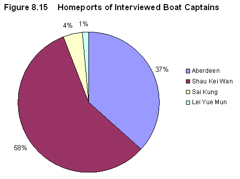
8.6.4.1
Semi-structured interviews with
68 fishing boat captains from Shau Kei Wan, Lei Yue Mun, Sai Kung and
8.6.4.2
Figure 8.15 presents the
breakdown of interviewees to homeport.
Most interviews were held at Shau Kei Wan which supports a relatively
large number of vessels fishing in Eastern Waters. Very few fishing vessels were harboured in
Sai Kung or Lei Yue Mun, with only a small number of interviewees from these
homeports.
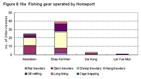
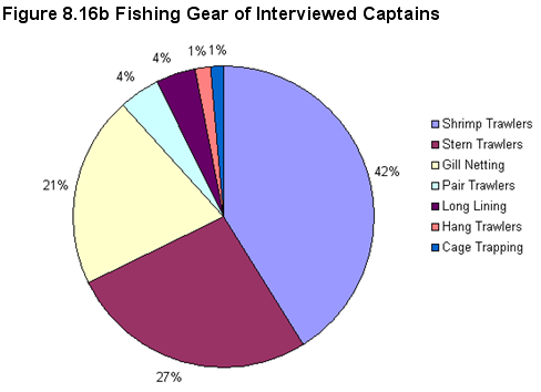
8.6.4.3 Figure 8.16a and b show the type of fishing gear used by the interviewees All vessels are family-owned with an average of four crew members per vessel on board. An average of two family members work on board, with other crew recruited from the Mainland to minimise operating costs.
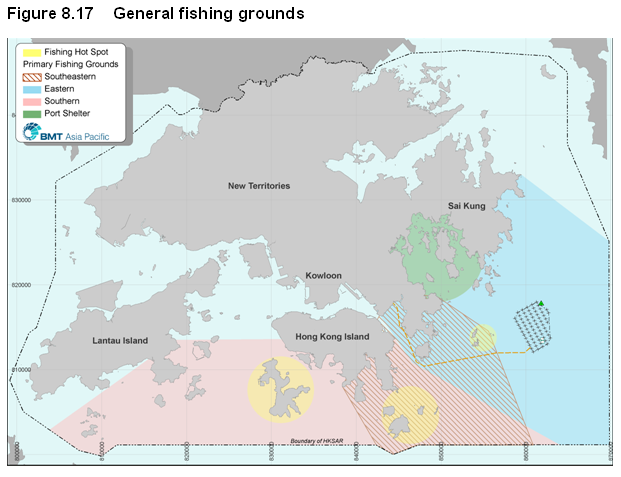
8.6.4.4 Figure 8.17 displays the primary fishing grounds with have been broadly defined as eastern, southern, south-eastern and Port Shelter. According to the interviewees, most fishing activity is conducted in ‘hot spots’ around Po Toi and the Ninepin Islands which is entirely consistent with the marine traffic radar data and visual observations of fishing activity made during the fisheries baseline studies.
8.6.4.5
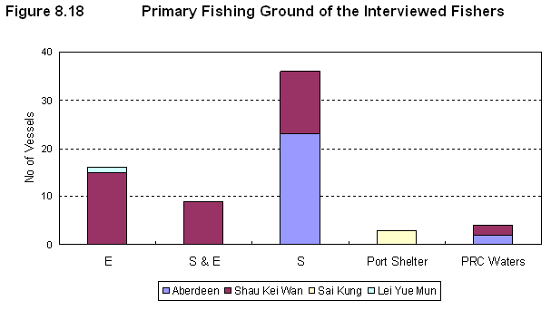
Figure 8.18 illustrates the
relationship between homeport and fishing ground. It is noted that about ~40% of Shau Kei Wan
respondents fished exclusively in Eastern Waters, while almost all
8.6.4.6 Specific observations of the homeports visited were made during the survey:
·
·
Shau Kei Wan is a smaller homeport than
· Sai Kung is dominated by recreational vessels. Only a few small craft were evident at the homeport, with few commercial fishing vessels seen.
· Lei Yue Mun was described as “dead” by interviewees as only two large (>15m) commercial fishing vessels were seen during two visits.
8.6.4.7 From all interviewees, a total of 23 species of fish species were reported as being among the ‘top five’ most commonly caught fish. Figure 8.19 presents a summary of common caught species, with data for Shau Kei Wan isolated as a proxy for the general catch in Eastern Waters.
8.6.4.8
Shau Kei Wan respondents
reported 16 common species (excluding fry and mixed
fish) with the common catch being ‘shrimp’, ‘crab’, flathead, tongue sole and
croaker. Only Shau Kei Wan interviewees
also reported scad among the common catch, with the Port Survey 2006 indicating
very high productivity of this species around the
8.6.4.9
With reference to Figure 8.19 the top ten
most commonly caught species have been identified and an indicative value has
been assigned based on mean wholesale prices (HK$ / kg) as published by the Fish Marketing Organization (FMO) in October 2007. Table 8.10 presents
this value ranking system, and Table
8.11 summarises the
assigned value for the species brought to Sha Kei Wan homeport.
Table 8.10 Indicative species value ranking system
|
Ranking |
Wholesale Price (HK$ / kg) |
|
Very Low |
up to 10 |
|
Low |
11 – 30 |
|
Moderate |
31 – 60 |
|
High |
61 – 91 |
|
Very High |
>90 |
Table 8.11 Value of common catch from Shau Kei Wan
|
Common Name |
Commercial Value |
|
Shrimp |
Low to high |
|
Crab |
Low to high |
|
Flathead |
Low
to medium |
|
Tongue sole |
Not available |
|
Croaker |
Not available |
|
Golden thread |
Very low to low |
|
Promfret |
Low
to medium |
|
Cardinal fish |
Very low |
|
Mackerel |
Very low |
|
Hairtail |
Low |
8.6.4.10 With reference to Table 8.11 it is apparent that the finfish species caught in Eastern waters are of relatively low commercial value, although the value of the crustaceans varies according to species and age.
8.6.4.11 The survey also asked fishermen the reasons for selection of preferred fishing grounds and reported four important factors (in order):
1. Proximity to homeport
2. Sea state
3. Abundance of fish resources
4. Familiarity with fishing ground(s)
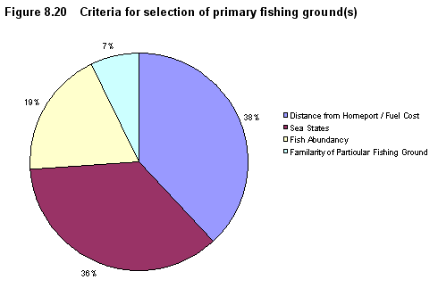
8.6.4.12 Figure 8.20 summarises the responses. The main reason for selection was proximity to homeport which was stated as a crucial factor in controlling fuel costs which continue to rise. The abundance of fish and familiarity with the fishing ground(s) were reported as being of less importance.
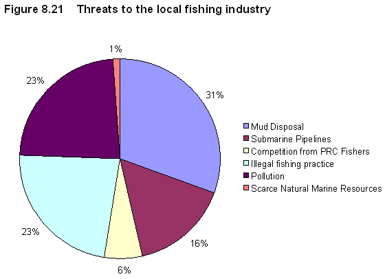
8.6.4.13 Following on from a more general discussion of threats facing the fishing industry six issues were identified:
8.6.4.14 Dredging and mud disposal were referred as the main threat, with these activities considered to be the key reasons for the decline in fish abundance over the past two decades.
8.6.4.15 Pollution was identified as the second biggest threats to the local fishing industry.
8.6.4.16 Illegal fishing practices, particularly the reported use of indiscriminate electro-fishing by Mainland fishermen.
8.6.4.17 Rock armour protection for submarine pipelines it was felt was responsible for damaging trawler nets, and a particular problem for vessels without sonar.
8.6.4.18 Competition from Mainland fishermen illegally operating in HKSAR waters.
8.6.4.19 Scarcity of marine resource within HKSAR waters was only considered by a small number of respondents to be a threat to the local fishing industry.
8.6.4.20 Figure 8.21 presents the relative significance of these threats.
8.6.5 Formal Consultation with Fisheries Organisations
8.6.5.1 A series of formal consultation meetings have been held with fisheries organisations. The key concerns raised by organisations consulted are as follows:
· Seabed impacts from Project construction creating major disturbance and fish kills.
· Implications for fishing vessel access into the wind farm, and if the Project would further reduce the fishing ground.
· Navigation and safety hazards from the presence of wind turbines.
· Concern regarding the responsiveness of emergency rescue.
8.7 Construction Phase Impact Assessment
8.7.1 Introduction
8.7.1.1 Potential impacts on fisheries during Project construction are:
· A decline in water quality associated with dredging, jetting and / or foundation installation.
· An increase hazard to fishing vessels due to increase in construction vessel movements; and
· Temporary loss of fishing ground due to necessary construction activity.
· Temporary, localized disturbance to spawning grounds due to jetting works.
8.7.2 Water Quality
8.7.2.1
The Project will require
cabling which will involve dredging in
8.7.2.2 All fish culture zones in the Study Area and potential sensitive receivers included in the numerical assessment of water quality impacts (Section 4 refers). Table 8.12 summarises the water quality results for unmitigated construction activities.
|
Fish Culture Zone / ID |
Peak Baseline |
Unmitigated concentration* /
Scenario |
||||
|
1 |
2 |
3 |
4 |
5 |
||
|
Ma |
3 |
3 |
3 |
3 |
3 |
3 |
|
Kau
Sai (FCZ2) |
41 |
41 |
41 |
41 |
41 |
41 |
|
Kai
Lung Wan (FCZ3) |
3.9 |
3.9 |
3.9 |
3.9 |
3.9 |
3.9 |
|
Leung
Shuen Wan (FCZ4) |
130 |
130 |
130 |
130 |
130 |
130 |
|
|
8.1 |
8.1 |
8.1 |
8.1 |
8.1 |
8.1 |
|
Tung Lung
Chau (FCZ6) |
8.4 |
8.4 |
8.4 |
8.4 |
8.4 |
8.4 |
|
Tai
Tau Chau (FCZ7) |
16 |
16 |
16 |
16 |
16 |
16 |
|
|
15 |
15 |
15 |
15 |
15 |
15 |
8.7.2.3 Despite the proposed cable installation activity in the Tathong Channel, the modelling results indicate that levels of suspended sediment at the Tung Lung Chau fish culture zone will not exceed baseline levels. Levels of dissolved oxygen at the fish culture zone will also not be affected by cable installation. Accordingly, there shall be no adverse impacts at any fish culture zone during construction.
8.7.2.4 With regard to capture fisheries, Table 8.13 displays the predicted mixing zone associated with marine construction activities.
Table 8.13 Mixing zone radii for marine construction activities
|
|
Construction method |
||
|
Jetting |
Dredging |
Suction Caisson |
|
|
Dry |
< |
< |
< |
|
Wet |
< |
< |
< |
|
m above seabed |
1.5 – 3.0 |
Entire water column |
< |
8.7.2.5 As fish are highly mobile and the large volume of seawater in which to swim, the relatively small mixing zones are not anticipated to cause any significant adverse impacts on capture fisheries.
8.7.2.6 As demonstrated by Port Survey data, fish fry productivity is negligible in the Study Area although water quality impacts are not in any case anticipated. No areas of coral reef that could potentially offer localised spawning and nursery habitat for capture fisheries recruitment will be adversely affected by construction activities (sub-section 5.7.3 refers).
8.7.3 Hazard to Fishing Vessels
8.7.3.1 During the construction of the wind farm, the increased marine traffic flow within the site and along the proposed cable routes will pose an additional marine navigation risk. The identified risks include:
· Construction vessel collision on-site
· Construction vessel collision with structure
· Construction vessel encounters (Jack-ups or anchors) underwater obstruction (Cable, pipeline etc)
· Construction vessel jacks-up or anchors onto unexploded ordnance
· Man overboard during personnel transfer operations
· Dropped Object during major lifting operations
8.7.3.2
Therefore, a
8.7.3.3
It is
anticipated that as major sections of the windfarm are installed the footprint of
the waterspaces is progressively designated as a controlled waterspace through
the deployment of byelaws or similar legal instruments that will be sought for
the windfarm site. Waterbourne access
would be restricted to vessels that have received approval from the authority
specified in the legal instruments.
8.7.4
Impact to Traditional Fishing Ground
8.7.4.1
All
vessels will be restricted from accessing the safety / exclusion zone during
installation of cable routes and turbine construction, and hence a temporary loss
of fishing ground will occur.
8.7.4.2
As
presented in the baseline, relatively little fishing takes place at the wind
farm site and restrictions on access will be over a small area. Construction activities may drive fish away
from the area and consequently the implementation of restricted access measures
will not result in any significant adverse impacts. Accordingly, there shall be no significant
adverse impacts on fisheries due to loss or restricted access to traditional
fishing ground.
8.7.5 Impact to Spawning and Nursery Grounds
8.7.5.1
The wind farm footprint lies
more than 4km away from the identified spawning grounds in eastern
8.7.5.2
Both the wind farm site and the
cable route lie far from important nursery sites of commercial species in Hong
Kong (in Northeast Waters, within Port Shelter, south of Lamma Island and south
of Lantau).These identified sites which will not be affected by the Project
works.
8.7.5.3
Table 8.14 Summary of Construction Phase
Impacts
|
Critera |
Description |
|
Nature of impact |
Impacts are temporary and short term. |
|
Size of affected area |
500m radius
safety / exclusion zone and wind farm footprint progressively designated as a controlled
waterspace. This represents a small area of a low-productivity section of |
|
Loss of fisheries resources / production |
Temporary access restrictions to relatively
low-productivity fishing grounds. |
|
Destruction and disturbance of
nursery and spawning grounds |
No impact on nursery grounds. Jetting will cause temporary localized
disturbances (mainly displacement of fish) along the cable corridor. The
total cumulative extent of areas that may be disturbed comprise a tiny percentage
(0.6%) of spawning grounds in eastern waters. |
|
Impact on fishing industry |
Temporary access restriction to a small, relatively low-productivity and low
fishing intensity section of |
|
Impact on aquaculture industry |
No impacts on the aquaculture industry, |
8.8 Operational Phase Impact Assessment
8.8.1.1 As identified in Section 4, the operation of the wind farm project will not induce any water quality impacts. Potential impacts on commercial fisheries lie in:
· Potential hazard to fishing vessels;
· Permanent loss of fishing ground, and
· Potential for beneficial impact on fisheries in the wind farm area.
8.8.2
Hazard to Fishing Vessels
8.8.2.1 A Marine Navigation Safety Risk Assessment (MNSRA) has been conducted to assess impact of the wind farm on the existing and future marine traffic profile in south-eastern waters (Appendix 2A refers).
8.8.2.2
The assessment included a
comprehensive analysis of the marine navigation safety risk implications
arising from the establishment of an offshore wind farm in south-eastern
8.8.2.3 However, a review of the key risks identified a series of hazards that cannot be readily mitigated by engineering / operational measures alone. These hazards are associated with a variety of “created behaviours” that may be displayed were unrestricted marine activity to be permitted, and include:
· Scaling turbines for fishing with the potential for falls, or stranding on turbines due to boats being unable to return and pick-up;
· Capsizing due to un-seaworthy vessels accessing the wind farm area for sight-seeing activities; and
· Trawlers snagging nets / colliding with turbines whilst taking advantage of the anticipated local aggregation of fish.
8.8.2.4 The MNSRA concluded that restriction is required to manage “created behaviours” anticipated within the wind farm area. In order to manage these risks it is proposed that the Windfarm area is designated as a controlled waterspace through the development of byelaws or similar legal instruments. Waterbourne access would be restricted to vessels that have received approval from the authority specified in the legal instruments." The following vessel restrictions are proposed:
· Marine vessel management with a designated Marine Restricted Area;
· Trawling activity would be prohibited;
· Permitted marine vessels would include all Government vessels and wind farm maintenance vessels, and may be extended to include dive boats, tourist launches, hand-line fishing vessels, etc.; and
· Permitted marine vessels are anticipated to be required to carry Automated Identification System (AIS) transmitters to monitor and safeguard their operations, and ensure they are seaworthy for offshore conditions.
8.8.3 Impact to Commercial Fishing Activities
8.8.3.1
Considering all fishing vessels
will be excluded from the wind farm area for marine navigation safety reasons,
a total of <
8.8.3.2 However, the following characteristics of the proposed wind farm site discount its overall value to the local fishing industry:
· Uniform and exposed muddy seabed with no habitat diversity is unattractive to fish as a shelter or feeding area.
· Very limited to no spawning activity in the area specifies its low importance as a potential spawning / nursery ground for replenishing depleted fisheries (ERM , 1998).
· Low productivity and commercial value in waters..
· Rough sea conditions for much of the year make it unsafe for smaller vessels to operate in this area.
· Remoteness of the site coupled with it large expanse and low productivity decreases its commercial value due to the high fuel cost.
8.8.3.3 While the wind farm components will only occupy the equivalent of ~0.3% of the entire wind farm footprint (see 5.7.2.14), the remaining 99.7% will remain as open waters and viable habitat for the existing fish stock. Accordingly, set against the low baseline fisheries productivity and hence value of the wind farm area, a negligible adverse impact on the fisheries stock habitat of Eastern waters may be anticipated..
8.8.3.4 The existing baseline productivity of capture fisheries in the Study Area is low. Given the proposed management of the site area in relation to the Project, the waters in the site area could be used as a fisheries enhancement area. This is beyond the scope of this EIA and Project, but the Project Proponent acknowledges the potential, Sub-section 8.8.4 presents options for potential benefits to fishery.
8.8.4 Potential Benefits to Fisheries
8.8.4.1 Danish Offshore Wind Farms
8.8.4.2
The Danish Energy Authority conducted an environmental monitoring
programme between 2000 and 2006 for the two Danish offshore wind farms (DONG
Energy et al, 2006):
·
Horns Rev Offshore Wind Farm,
operational since 2002, is located 14
·
Nysted Offshore Wind Farm
commissioned in 2002-2003 consists of 72 turbines situated
8.8.4.3 This study provides qualitatively evaluation on the actual environmental performance at the wind farm sites during the operation phase. The key findings of this monitoring study related to fishery resources are summarised as follows:
· Presence of wind farm structures: The overall habitat heterogeneity and species richness has increased as a result of introducing artificial structures in the previously homogenous sandy seabed, permitting colonisation by an epibenthic community.
· Exclusion of fishing activity in the wind farms: The absence of fishing activity, particularly trawling, is deemed key to boosting the abundance and diversity of the benthic ecosystem.
· Impacts on fish communities as a result of operation of the wind farms: Statistically, no adverse impacts on fish population have been identified. The study has forecasted that the potential for enhancing fish supply cannot be overlooked once the benthic communities become fully established in the wind farm areas.
8.8.4.4
Dive Observations at
Offshore Oil and Gas Platforms in the
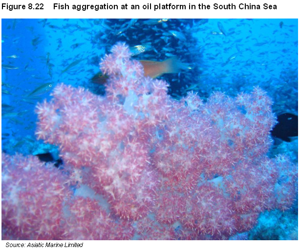
8.8.4.5
With reference to sub-section 5.8 the established marine fouling and
coral communities on the surface of the oil and gas platforms in the
8.8.4.6
Predator fish species such as
barracuda, tuna and snappers have been observed in the area with some of the
fish size reach as long as
8.8.4.7 Opportunities for the Local Fishing Industry
8.8.4.8 With the exclusion of all fishing vessels within the wind farm area, losses primarily of highly resilient species and juvenile fish from trawling and other non-trawling fishing activity will cease. The wind farm area is therefore potentially beneficial to fisheries resources.
8.8.4.9
Based on the Baseline Site
Design, presented in Section 2.6, it is expected that the marine foundation
structures will offer a cumulative surface area of >100,000 m2
(67 tripod structures with legs nominal 5m diameter in 30m water depth) This
area would be available as an artificial reef substrate for colonisation by
epibenthic flora and fauna, including communities of corals similar to those
found at the offshore oil and gas platforms in the South China Sea to the south
of the proposed wind farm. Species with a preference for low light and low /
medium current speeds such as the black coral Cirripathes sp. could also colonise the foundation structures.
8.8.4.10 Once the artificial reef systems begin to develop, natural (unaided) spawning / nursery area are likely to become naturally established (Error! Reference source not found. refers). Assisted spawning / nursery areas may also be achieved through manual stocking of fry and larvae in the wind farm area to supplement naturally recovering fisheries resources.
8.8.4.11 Overall the proposed wind farm project and the proposed restrictions on fishing activity in the wind farm area provide an opportunity to replenish the heavily exploited fisheries resources in Eastern Waters. Establishment of artificial reef communities on marine foundations will benefit the overall abundance and diversity of fisheries resources, and will provide a test case for further large scale fisheries protection and sustainable fisheries management in the HKSAR.
8.8.4.12 If after the EIA process has been completed, Government, other agencies or key stakeholders would like to implement enhancement and management of fisheries resources within the wind farm site, beyond those already inherent within the Project’s design and management (i.e. the potential for turbine substructures to naturally act as artificial reefs and the management of the windfarm footprint as a controlled waterspace), the Project Proponent will work with such bodies in the context of an initiative led by a 3rd party to formulate and explore such additional measures.
8.8.5 Summary of Operational Phase Impacts
|
Critera |
Description |
|
Nature of impact |
Long term,
permanent presence of wind farm and associated fishing exclusion zone |
|
Size of affected area |
16km2 are of wind farm footprint. However wind farm
tower components only occupy about 0.3% of the site with the remaining 99.7%
of open waters available as viable habitat for fish. |
|
Loss of fisheries resources / production |
Loss of 16km2 of
relatively low productivity fishing grounds. This is equivalent to less than
1% of the Nevertheless, some local fishermen (particularly trawlers) who habitually fish in the wind farm site will be affected to a limited extent. Potential benefits from >100,000 m2 of turbine substructures available as artificial reef substrate for fishery enhancement by providing rare deep water substrate. |
|
Destruction and disturbance of
nursery and spawning grounds |
No adverse impact
on important nursery and spawning grounds
Presence of tower structures provides potential habitat |
|
Impact on fishing activities |
Loss of 16km2 area of relatively low-productivity and
low-fishing intensity fishing grounds. |
|
Impact on aquaculture
activities |
No impact on
aquaculture activities. |
8.9.1.1 As presented in Section 4, no cumulative water quality impacts are anticipated as a result of the operation of the East Ninepins and East Tung Lung Chau Sediment Disposal Areas, or from construction activities associated with Further Development of Tseung Kwan O.
8.9.1.2 No cumulative impacts are anticipated during operation of the proposed wind farm.
8.10 Mitigation Measures & Best Practice
8.10.1.1 As the fisheries impacts are directly associated with the water quality, therefore, mitigation measures and best practices to avoid water quality impacts presented in Section 4 of this EIA Study Report shall be adopted and implemented during the works.
8.10.1.2 No significant adverse impacts are expected during the operational phase.
8.11 Potential Benefits
8.11.1.1 Positive impacts are anticipated following the implementation of the fishing exclusion zone at the wind farm site which would contribute to effective fisheries resource enhancement in Eastern Waters.
8.11.1.2 As referred in sub-section 8.8.4, the sub-structure of the wind turbine foundations shall provide a net increase in the surface area of hard substrate available as an artificial reef for colonization by reef dwelling organisms.
8.12 Residual Impact Assessment
8.12.1.1 No significant residual impacts are anticipated during construction and operational phase of the wind farm.
8.13 Environmental Monitoring & Audit Requirements
8.13.1.1 As no significant adverse construction and operation phase impacts are anticipated, no environmental monitoring and audit is proposed.
8.14 Conclusions & Recommendations
8.14.1.1
The Project will lead to the
permanent loss of approximately 16 km2 of relatively low
productivity / value fishing ground within
8.14.1.2
No significant water
quality-induced impacts are predicted on the popular fishing area around the
8.14.1.3 The operational Project will lead to loss in fishing ground, although the potential for a significant net positive impact may be achieved.
AFCD Fisheries: http://www.afcd.gov.hk/english/fisheries/fish_abt/fish_abt.html
AFCD, (1997). Fishing Vessel Count, 1997.
Agriculture and Fisheries Department,
AFCD, (1998). Port Survey 1996/97. Agriculture and Fisheries Department.
AFCD, (2003). Port Survey 2001/02. Agriculture Fisheries and Conservation Department.
AFCD, (2008). Agriculture Fisheries and Conservation Department website.AFCD, http://www.afcd.gov.hk/english/fisheries/fish_aqu/fish_aqu_mpo/fish_aqu_mpo.htmlAsiatic Marine Limited, (2007). Interview.
Cheung W.L.
(2001). Changes in
Cheung, W.W.L. and Sadovy, Y.
(2004). Retrospective evaluation of data-limited fisheries:
a case from
DONG Energy, Vattenfall, The Danish Energy
Authority and The
Environmental Resources
Management Consultants Hong Kong Ltd. (1998). Fisheries
Resources and Fishing Operations in Hong Kong Waters, Final Report, Agriculture
and Fisheries Department,
Fish Marketing Organisation website (http://www.fmo.org.hk/).
HK Fish Net website
(http://www.hk-fish.net/index.htm)
Ho, L. (2007). Linkage. Home Affair Bureau, HKSAR, 99-103pp.
Hong Kong Artificial Reef Project website (http://www.artificial-reef.net/English/main.htm)
Lee S.Y.,
Blackmore G. and Rainbow P.S. (2000).
Change in the epibenthic crab assemblages of the southeastern waters of
Leung, A.W.Y. (2000). Effects on the benthic fish fauna during and after large-scale dredging in the southeastern waters of Hong Kong. In: The Marine Biology of the South China Sea (ed. B. Morton). Proceedings of 3rd International Conference on the Marine Biology of the South China Sea. Hong Kong University Press, 651-672.
Leung, A.W.Y. (2003). Temporal Trends in Fish Abundance and Species Composition on an
Open Access Artificial Reef in
Leung, S.F.
and Leung, K.F. (2000). The prawn resources of the southeastern waters
of
Sadovy, Y. (1998). Patterns of reproduction in marine fishes of
Sumaila, U.R.,
Cheung, W.W.L. and Teh, L. (2007). Rebuilding Hong Kong‘s Marine Fisheries: An
Evaluation of Management Options. Fisheries Centre,
Williamson, G.R., (1968). A biologist looks at